The Warburg Institute is pleased to announce a major exhibition exploring the styles and stakes of mapping the night sky. Curated by Warburg Professor John Tresch in partnership with The Sunderland Collection, a cultural heritage collection containing world maps from the 13th–19th centuries, Night Maps traces the entangled histories of cosmic imagination and earthly power. From medieval courts and cathedrals to moon landings and satellite surveillance, the exhibition reveals how depictions of the heavens have been made to serve rival systems on earth – and how these mythical flights continue to shape the worlds we share.
Night Maps reveals how maps of the skies have served as both poetic visions and tools of government on land. From Taoist priests and imperial administrators in second-century China who envisioned the skies as a ‘celestial bureaucracy’, to Renaissance astronomers, colonial naval officers, and Cold War cosmonauts, the night sky has been a canvas for the writing and rewriting of power, where myth guides technology, and observation serves earthly ambitions. Inscribed with gods and monsters, data and diagrams, these maps ask: how do structures of control and containment imprint themselves onto the vastness of the night sky?
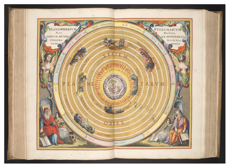
Highlights of the exhibition, drawn from The Sunderland Collection and on public display for the first time, include the first printed edition of Ptolemy’s Almagest; an illustrated manuscript by 12th-century cosmologist William of Conches; a monumental Chinese blue celestial map from 1822 which updated Chinese astronomy with Western geography; one of seven known examples of the allegorical ‘Christian Knight’ Map which inspired John Milton’s Paradise Lost; a rare 18th-century Nepalese bhūgola or ‘world diagram’ whose contemplation strengthened rulers’ force and virtue; and an engraved stone cosmogram from the ancient Valdivian culture of Ecuador dating to 2000 BC. The exhibition will also include slides and photographs from the UCL/NASA Regional Planetary Image Facility (RPIF), on public view for the first time, as well as material drawn from the Warburg Institute’s collections. Aby Warburg’s interest in the long cycles of influence of astrological imagery on art and philosophy led him to curate an exhibition for Hamburg’s Planetarium shortly before his death in 1929. Material relating to this exhibition, as well as three iconic panels from Warburg’s unfinished final work Bilderatlas Mnemosyne, will be on display in Night Maps.
The exhibition unfolds across four interconnected sections, tracing how the heavens have been observed, imagined, ordered, and put to work. It opens with ‘Myth and Logic’, which shows the constant interaction between precise astronomical knowledge and mythological projection, where human observers and calculators contend with ancient, personified constellations and the pressure of obscure forces enveloping the earth. ‘Celestial Bureaucracies’ follows, examining how star maps conjure up elaborate systems of terrestrial administration, accounting, and time- and record-keeping on earth. ‘Claiming Space’ explores how celestial knowledge is mobilised in the service of governance, from royal and imperial cosmologies to modern military and corporate space-race cartographies. The exhibition concludes with ‘Satellite States’, in which contemporary maps, digital and video works detail the tight entwinement of space, surveillance and planetary orientation today.
A full public programme, including a live podcast recording of the award-winning What’s Your Map?, a full-day symposium, and talks, events and workshops will accompany the exhibition.
Night Maps is curated by John Tresch, Professor of History of Art, Science, and Folk Practice at the Warburg Institute. The exhibition is generously supported by mapping and location technology specialist TomTom.
We are delighted to present Night Maps, the kind of exhibition project the Warburg’s gallery was created to support, bringing our collections and research into close conversation with objects and ideas from the wider cultural landscape. Working with The Sunderland Collection allows us to trace how images of the night sky carry histories of science, belief, empire and imagination across time and space, giving us a unique opportunity to make the Warburg’s methods visible to a wider public through objects and artworks that are both intellectually and visually compelling.” Matthew Harle, Curator of Artistic Programmes at the Warburg Institute
This is the first exhibition of celestial maps from The Sunderland Collection, and we are thrilled to be debuting them at Night Maps. The Warburg Institute’s focus on cultural history and images is an ideal forum for thinking about what the cosmos has meant to humans over time, and how – and why – it has been represented graphically. We are also delighted by the amount and range of programming being planned for this exhibition. The project as a whole is very timely, given the recent Artemis voyage to the moon, and ongoing discussions among sovereign states about colonising space. It shows how timeless some of these issues are.” Helen Sunderland-Cohen, Director of The Sunderland Collection
Night Maps is at The Warburg Institute in London from 21 October 2026 until 17 April, 2027. Find more information here.